

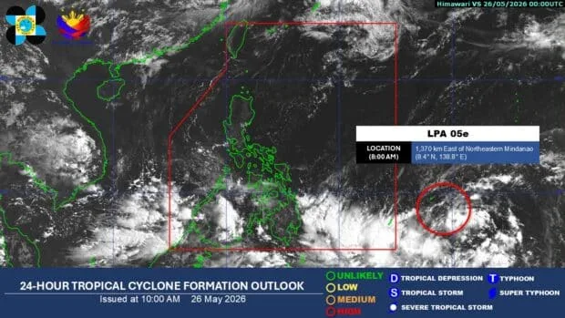
A low-pressure area (LPA) located outside the Philippine Area of Responsibility (PAR) has a high likelihood of developing into a tropical depression within the next 24 hours. The Philippine Atmospheric, Geophysical and Astronomical Services Administration (Pagasa) reported this, stating that the system may enter PAR this weekend, particularly on Friday or Saturday.
The bureau spotted the LPA at 1,370 kilometers east of northeastern Mindanao as of 8 a.m. on Tuesday, May 26. It's likely that once it enters PAR, it may trigger the southwesterly winds, or warm and moist air from the west. This could bring rains to parts of the country.
The LPA is currently being monitored by Pagasa, which is the state weather bureau responsible for providing weather forecasts and warnings to the public. They're using various tools and techniques, including satellite imaging and computer models, to track the movement and development of weather systems like the LPA.
According to Pagasa, the LPA has a high chance of becoming a tropical depression due to favorable weather conditions. If it develops into a tropical depression, it will be given a name. Pagasa will then closely monitor it.
The possible entry of the LPA into PAR this weekend may bring rains to parts of the country, particularly in the eastern sections of Mindanao and the Visayas. The public is advised to monitor the weather forecast and warnings from Pagasa. They should also take necessary precautions in case of heavy rains and strong winds.
In the Philippines, tropical depressions and storms are a common occurrence during the rainy season, which typically starts in June and lasts until November. The country is located in the Pacific typhoon belt. It's prone to typhoons and storms that can bring heavy rains and strong winds.
'We are closely monitoring the LPA and will provide updates on its movement and development,' said a Pagasa official.
The public is advised to stay tuned to local news and weather reports for updates on the LPA and any other weather systems that may affect the country. It's also important to have a plan in place in case of emergencies. This plan should include having a first aid kit and a battery-powered radio on hand.
In recent years, the Philippines has experienced several devastating typhoons and storms, including Typhoon Yolanda, which hit the country in 2013. It caused widespread damage and loss of life. The country has since improved its disaster preparedness and response efforts. However, the public is still advised to be vigilant and prepared for any weather-related emergencies.
The possible entry of the LPA into PAR this weekend is a reminder of the importance of disaster preparedness. It highlights the need for the public to stay informed and vigilant. By monitoring the weather forecast and warnings from Pagasa, the public can help minimize the risks and impacts of weather-related disasters. They can also take necessary precautions to ensure their safety.
Key Facts
- The LPA is located 1,370 kilometers east of northeastern Mindanao
- It has a high chance of becoming a tropical depression within the next 24 hours
- The system may enter PAR this weekend, particularly on Friday or Saturday
- The LPA may trigger the southwesterly winds, or warm and moist air from the west
- The public is advised to monitor the weather forecast and warnings from Pagasa and to take necessary precautions in case of heavy rains and strong winds
The Philippine government has implemented various measures to reduce the risks and impacts of weather-related disasters. These measures include the establishment of early warning systems. They also include the conduct of disaster preparedness and response training for local officials and communities. The public is also encouraged to participate in disaster preparedness and response efforts. They can do this by staying informed, having a plan in place, and taking necessary precautions in case of emergencies.
By working together, the government, the public, and other stakeholders can help minimize the risks and impacts of weather-related disasters. They can promote a safer and more resilient community. The public won't be caught off guard if they're prepared and informed. They'll be able to respond quickly and effectively in case of an emergency.